| Command | CAPCAD_SIGNS_FIX |
| Shortcut | CV |
| Ribbon | CapCad tab › Sinalização Vertical panel › Vertical split button › Corrige Vertical [CV] |
| Category | Vertical |
| Form | CorrigeForm, titled Vertical Tools (modeless: the drawing stays live while it is open) |
| Hosts | AutoCAD (on ARES Commander the command exists and answers with a "not available" notice) |
| Also open the same form | CAPCAD_SIGN_TOOLS (opens on the Ferramentas tab), CAPCAD_ACTION_PANEL (opens on the Ações tab) |
| Related commands on this page | CAPCAD_SIGN_BLOCK_FIX (fixes ordinary blocks), CAPCAD_SIGN_FILL / -CAPCAD_SIGN_FILL (shortcut VA, validates a sign's own dwg) |
One command gives the whole of the drawn signing its coherence back, after the project changed underneath it. Moving signs, redefining the alignment, changing the coordinate system or switching the design paradigm leaves hundreds of blocks carrying stale attributes. Here that is settled in a single pass.
- Re-stations everything against the project alignment. Every sign is projected onto the alignment and receives the resulting station or kilometre, spelled the way the alignment and the style ask.
- Measures the coordinate where it really is. The measured point is the post's, not the sign's — including the offset of a cantilever arm — so a sign shifted off its post does not spoil the coordinate.
- Local and geographic coordinates together. X/Y, E/N and latitude/longitude all come from the same point, at the precision you choose, and the coordinate system comes from the project.
- Area and dimensions checked against the norm. Conventional signs receive the recommended size for the road type or highway class; the others are measured on the block itself.
- Layers, codes and marks in the same sweep. The code comes from the block name, the layer comes from the action, and the marks and ordinary blocks in the same selection can be fixed along with them.
- Orphan signs become a visible problem. A sign with no post is counted, can be given a leader line back to the origin, and is never fixed in the dark.
What it does
A CapCad sign is not just a block: it carries its own design data in attributes — station/km, X/Y, easting/northing, latitude/longitude, alignment name, code, dimensions, area, action — and its layer states its action (implant, keep, remove, substitute). That data is computed at insertion time, against the alignment and the coordinate system of that moment.
When something changes afterwards — the alignment is redrawn or re-imported, the project coordinate system is defined, a sign is dragged to its proper place, the design paradigm starts demanding a different station spelling — all of those attributes are lying. CAPCAD_SIGNS_FIX is the command that recomputes them. It sweeps a selection (or the whole drawing), separates out what is a sign, and for each sign:
- Decides whether it is in scope, from the action read off the layer or the attribute, according to the Aplicar em placas em situação boxes.
- Finds the sign's post through a five-step geometric ladder (insertion point within 1 unit, a fence over the block geometry, a hop along the leader line, a widened fence and, last, the assembly path). If none is found, the sign is an orphan.
- Chooses the measuring point: the post's point (already corrected by the
Position3parameter and turned by the post's rotation), displaced along the post when it is a cantilever arm. With no post, the sign's own point — but only if you ticked Usar o ponto de inserção da placa (15); otherwise the sign is left untouched. - Rewrites the coordinates:
PLACA_X,PLACA_Y,PLACA_ESTE,PLACA_NORTE,PLACA_LAT,PLACA_LON,LATITUDE,LONGITUDE,PLACA_LAT_LONandPLACA_EIXO. - Rewrites the station:
PLACA_KM,PLACA_ESTandKM, by stationing the point on the project alignment. - Rewrites dimensions and area:
PLACA_DIM,PLACA_DIM_AREAandPLACA_AREA. - Rewrites the code and the layer:
PLACA_CODfrom the block name, and the sign's layer (and optionally the post's) from the action.
The whole sign sweep happens in a single transaction, written out at the end in one go.
What the command does not do
- It moves nothing, rotates nothing and resizes nothing. It only writes attributes and changes layers. Rescaling signs already inserted is a separate button, under Ferramentas ▸ Escala ▸ Ajusta escala (42); rotation relative to the alignment is decided at insertion and by the sign-to-post fitting command, not here.
- It does not update a sign after a style change. The command writes values into attributes that already exist in the block: a missing tag is simply ignored. Changing the project style changes the sign's graphic definition and the set of attributes it should carry — that is the Styles Explorer's job (see Migrate the traffic-sign style). Run Fix Traffic Signs after the style migration, to fill the new attributes in — including ticking the area options if the dimensions came through empty.
- It does not invent a station without an alignment. With no alignment loaded in the project, the km block is skipped (rather than stamping "km 0+000" over real values) and the command says so on the command line.
- It does not invent latitude/longitude without a coordinate system. With no coordinate system defined in the project, the four geographic attributes are left as they were, and the command says so.
The two status labels
At the foot of the Corrigir tab sit two labels that read the project at the moment the form opens (and every time the command is called again): Eixo: (alignment) and Sistema de coordenadas: (coordinate system). Red = not defined; dark green = the alignment name and the system that were found. They are the quick diagnosis of why the station or the latitude/longitude will not be fixed. Once the run is over, the coordinate-system label is replaced by the result ("N corrigida(s), M órfã(s)." — N fixed, M orphaned).
The Estaca (station) box (5) follows the same facts: it is only enabled — and already ticked — when the project is urban or has an alignment. With neither, it appears disabled.
Workflow
- Run
CAPCAD_SIGNS_FIX(or typeCV). The Vertical Tools form opens beside the drawing, on the Corrigir tab. - Check the two labels at the foot of the tab: if the alignment or the coordinate system is red, settle that first in the Project Manager — otherwise the station and the latitude/longitude will not be fixed.
- Choose the scope: Selecionar (3) to pick in the drawing, or Desenho todo (4) to sweep the whole model space (paper space is never included).
- Tick what you want fixed in the Corrigir frame (5 to 13), what to do with post-less signs (14 to 16), the area options (17 to 20) and the criteria (21 to 27).
- On the opções tab, narrow the sweep to particular situations (32 to 37), choose the precision of the local coordinates (38) and decide whether marks (29) and ordinary blocks (30) join the same pass.
- Go back to the Corrigir tab and click Ok (1). The form hides during the selection and comes back afterwards.
- Read the report on the command line: how many signs were analysed, how many fixed, how many attributes written, how many in assemblies, how many orphaned — plus the warnings about a missing alignment and coordinate system.
The form
Numbers are the same in every screenshot of this page. The form has five tabs: Corrigir (fix), opções (options), Ferramentas (tools), Ações (actions) and Util.
This form shows Portuguese captions in every language, so the tables below quote the caption you will see on screen and give its English meaning beside it.
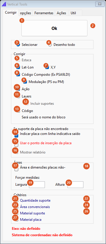
The "Corrigir" tab (1 to 27), in its opening state. The Estaca box (5) appears disabled because the sample drawing has no project with an alignment.
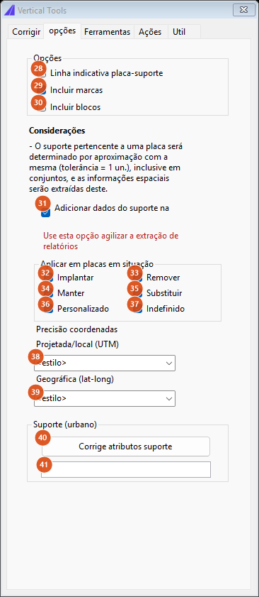
The "opções" tab (28 to 41).
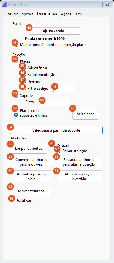
The "Ferramentas" tab (42 to 63).
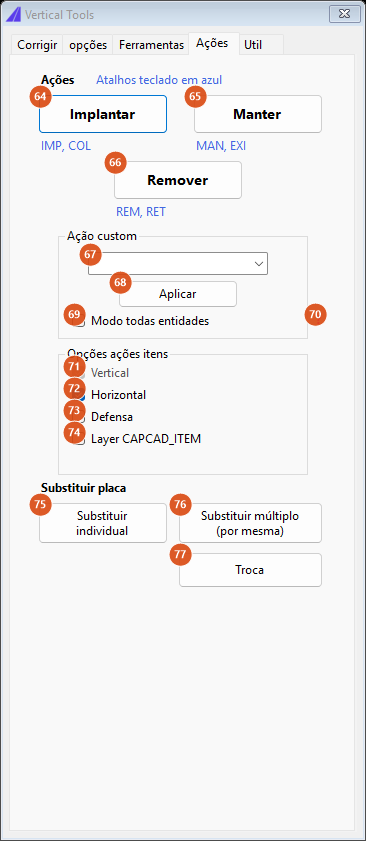
The "Ações" tab (64 to 77).
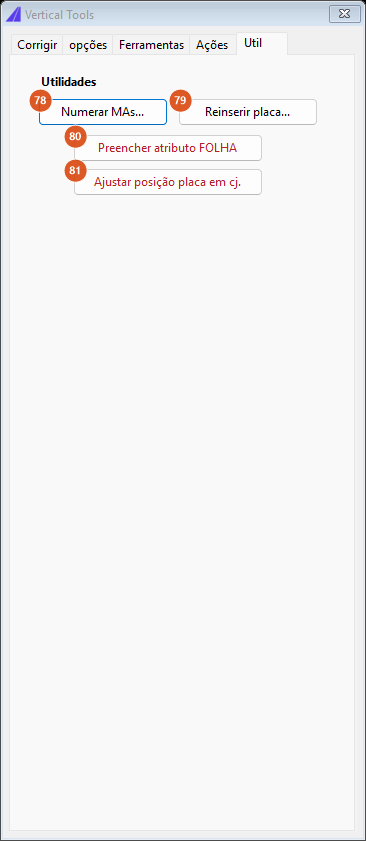
The "Util" tab (78 to 81).
Tab 1: Corrigir. Run and scope
| # | Control | What it does |
|---|---|---|
| 1 | Ok | Runs the fix. The form hides, the selection is made per 3/4, and the sweep runs in a single transaction. At the end the report goes to the command line and the form's bottom label shows the summary. |
| 2 | ? | Not available in this version. |
| 3 | Selecionar (Select) | Asks for a selection in the drawing. Cancelling the selection cancels the run. |
| 4 | Desenho todo (Whole drawing) | Sweeps the whole model space. Deliberately does not include paper space. |
Tab 1: Corrigir. The Corrigir frame
| # | Control | What it does |
|---|---|---|
| 5 | Estaca (Station) | Recomputes the sign's station/km against the project alignment and writes PLACA_KM, PLACA_EST and KM. Only enabled (and pre-ticked) when the project is urban or has an alignment; with no alignment loaded, the block is skipped even when ticked, with a warning on the command line. A sign whose NAO_CORRIGIR_KM attribute is true is spared individually. |
| 6 | Lat-Lon | Together with 7, switches the coordinate block on. ⚠ The two boxes do not split what is written: either one ticked is enough for X/Y, E/N, latitude, longitude and the alignment name all to be rewritten. With no coordinate system in the project, the four geographic attributes stay untouched and the command warns. |
| 7 | X,Y | See 6. |
| 8 | Código Composto (Compound code) | Not available in this version. |
| 9 | Modulação (Modulation) | Not available in this version. |
| 10 | Ação (Action) | Not available in this version. |
| 11 | Layers | Moves the sign to the layer of its action, resolved through the style's layer catalogue (SINA_VERT_IMP, SINA_VERT_MAN, SINA_VERT_REM, SINA_VERT_SUB, or SINA_VERT_<action> for custom actions). The layer is created if it does not exist. Read the note on the empty action in Notes before using it. |
| 12 | Incluir suportes (Include posts) | Also moves the paired post to the same layer. Only enabled while Layers (11) is ticked, and only has effect with it ticked. |
| 13 | Código (Code) | Writes PLACA_COD from the effective block name, stripping the style suffixes (-Normal, -GrayShaded, -BlackAndWhite, -XShaped, …) and the colour-variant ones (-OBRA, -LIMA). The text under the box — "Será usado o nome do bloco" (the block name will be used) — describes exactly that. |
Tab 1: Corrigir. The Se suporte da placa não encontrado frame (when the sign's post is not found)
| # | Control | What it does |
|---|---|---|
| 14 | Indicar placa com linha indicativa saído da coordenada 0,0 (Mark the sign with a leader from 0,0) | For each orphan sign, draws a line from its insertion point to the origin 0,0, on layer CAPCAD_PLACA_ORFA (created if missing). This is how orphans are found in a large drawing. |
| 15 | Usar o ponto de inserção da placa para cálculo de coordenadas e km (Use the sign's insertion point) | Without this box, an orphan sign is counted and left untouched. Ticked, the sign is fixed using its own insertion point as the measuring point. |
| 16 | Mostrar relatório (Show report) | Disabled. |
Tab 1: Corrigir. The Áreas frame
| # | Control | What it does |
|---|---|---|
| 17 | Área e dimensões placas não-convencionais (Area and dimensions, non-conventional signs) | Switches on the area/dimension fix for non-conventional (laid-out) signs: the block is measured in the drawing and the three tags receive WxH, WxH=A,AAm and WxH. |
| 18 | ? | Not available in this version. |
| 19 | Largura (Width) | Forces the width instead of measuring the block. Empty or zero = do not force. Forcing the measurement changes the computed area too, not only the text. |
| 20 | Altura (Height) | The same, for the height. |
Tab 1: Corrigir. The Critérios frame
| # | Control | What it does |
|---|---|---|
| 21 | Quantidade suporte (Post count) | Not available in this version. |
| 22, 24, 26 | ? | Not available in this version. |
| 23 | Área convencionais (Conventional-sign area) | Switches on the area/dimension fix for conventional signs: instead of measuring the block, the value comes from a table of recommended dimensions, keyed by the road type (or by the highway class, in one paradigm) read off the alignment at the sign's station. This box only produces a value under the Brazilian country profile; see the note below. |
| 25 | Material suporte (Post material) | Not available in this version. |
| 27 | Material placa (Sign material) | Not available in this version. |
Conventional-sign dimensions are available only under the Brazilian country profile. Under any other profile the box writes nothing and the three area tags stay as they were. The recommended-dimension tables themselves, keyed by road type and by highway class, are on the Portuguese edition of this page.
Tab 2: opções
| # | Control | What it does |
|---|---|---|
| 28 | Linha indicativa placa-suporte (Sign-to-post leader) | Not available in this version. |
| 29 | Incluir marcas (Include marks — ticked by default) | Before the sign sweep, fixes the marks (INFO blocks) that are in the same selection: latitude/longitude, INFO_EST, INFO_KM and INFO_LADO. A mark with a leader line is measured at the tip of the leader; a mark without one, at its own insertion point. Its report is separate, with with leader / without leader counts. |
| 30 | Incluir blocos (Include blocks) | Before the sign sweep, runs on the same selection what CAPCAD_SIGN_BLOCK_FIX does (see below): fills LATITUDE, LONGITUDE, KM and LADO on ordinary CapCad blocks. |
| 31 | Adicionar dados do suporte na placa ao corrigir (Add post data to the sign — ticked by default) | Not available in this version. |
| 32 to 37 | Implantar, Remover, Manter, Substituir, Personalizado, Indefinido (implant, remove, keep, substitute, custom, undefined) | Restrict the sweep to signs in the given situation. ⚠ With all six ticked (the default) no filter is applied — see Notes for the consequence on the Layers box. Unticking at least one switches the filter on. |
| 38 | Projetada/local (UTM) (Projected / local) | Decimal places of the local coordinates written as X=… / Y=…. <estilo> uses the project style's format (one place by default, two under some paradigms); the other options are 0, 0.0 and 0.00. It does not affect E= / N=, which always use the style's format. |
| 39 | Geográfica (lat-long) | Not available in this version: latitude and longitude are always written with six decimal places. |
| 40 | Corrige atributos suporte (Fix post attributes) | Not available in this version. |
| 41 | (the text box beside it) | Not available in this version. |
The Considerações text block, between 30 and 31, is informative and describes the pairing ladder: the sign's post is determined by proximity (tolerance = 1 unit), assemblies included, and the spatial information is taken from it.
Tab 3: Ferramentas
| # | Control | What it does |
|---|---|---|
| 42 | Ajusta escala... (Adjust scale) | Rescales signs already inserted to the current scale in the preferences. Shows a warning first, then asks for a selection; for each sign it finds the post (and, in an assembly, the leader line and the second sign too) and scales the whole assembly about the post's insertion point. A sign already at the right scale is reported as such. |
| 43 | Manter posição ponto de inserção placa (Keep the sign's insertion point) | Changes the base point of the scaling. In an assembly, it scales about the sign's point instead of the post's. ⚠ On a lone sign with a post, ticking this box makes the scaling not happen (the conversion message is still printed). |
| 44 | Placas (Signs) | Selection mode: signs only. |
| 45, 46, 47 | Advertência, Regulamentação, Demais (warning, regulatory, others) | Not available in this version: the Placas mode does not filter by category. |
| 48, 49 | Filtro código (Code filter) and its box | Not available in this version. |
| 50 | Suportes (Posts) | Selection mode: posts only. |
| 51 | Filtro (the box beside Suportes) | Not available in this version. |
| 52 | Placas com suportes e linhas auxiliares (Signs with posts and auxiliary lines — default) | Selection mode: each sign plus its post, its leader line and the assembly's main sign. |
| 53 | Selecionar (Select) | Runs the mode chosen in 44/50/52 (CAPCAD_SIGN_SELECT, CAPCAD_SIGN_SELECT_POST or CAPCAD_SIGN_SELECT_ALL): asks for a selection, filters it, and hands the result back as the drawing's active selection. |
| 54 to 62 | Selecionar a partir de suporte, Limpar atributos (+ Vertical and Deixar atr. ação), Converter atributos para movíveis, Restaurar atributos para última posição, Atributos posição inicial, Atributos posição invertida, Mover atributos | Not available in this version. |
| 63 | Justificar (Justify) | Not available in this version. |
Button 42 uses the scale from the preferences; the Escala corrente: 1:1000 label above 43 is fixed text.
Tab 4: Ações
The three big buttons apply the action to a selection; the blue aliases beside them (IMP, COL / MAN, EXI / REM, RET) are the spellings CapCad recognises in layers and attributes, and the Atalhos teclado em azul label reminds you that those actions also have keyboard shortcuts.
| # | Control | What it does |
|---|---|---|
| 64 | Implantar (Implant) | Runs CAPCAD_ACTION_IMPLANT. |
| 65 | Manter (Keep) | Runs CAPCAD_ACTION_MAINTAIN. |
| 66 | Remover (Remove) | Runs CAPCAD_ACTION_REMOVE. |
| 67 | Ação custom (combo) | Where the name of a custom action is typed. The list comes through empty. |
| 68 | Aplicar (Apply) | Not available in this version: with 67 filled in, the command answers on the command line that custom actions are not available in this version; with 67 empty, it asks for the action first. |
| 69 | Modo todas entidades (All-entities mode) | Not available in this version. |
| 70 | ? | Not available in this version. |
| 71 to 74 | Vertical (ticked and disabled), Horizontal, Defensa, Layer CAPCAD_ITEM | Not available in this version. |
| 75 | Substituir individual (Substitute, single) | Runs CAPCAD_SIGN_SUBSTITUTE: keeps both signs — the new one as implant, the old one just below it as remove, joined by a line. |
| 76 | Substituir múltiplo (por mesma) (Substitute, multiple) | Runs CAPCAD_SIGN_SUBSTITUTE_MULTI. |
| 77 | Troca (Swap) | Runs CAPCAD_SIGN_SWAP: replaces the chosen sign with one of a code you give, keeping position, rotation, scale, attributes, dynamic properties and the existing action. Keeps one sign only — the opposite of 75. |
Tab 5: Util
| # | Control | What it does |
|---|---|---|
| 78 | Numerar MAs... (Number alignment markers) | Not available in this version. |
| 79 | Reinserir placa... (Re-insert sign) | Not available in this version. |
| 80 | Preencher atributo FOLHA (Fill the SHEET attribute) | Not available in this version. |
| 81 | Ajustar posição placa em cj. (Adjust the sign's position in an assembly) | Not available in this version. |
How the options combine
The tables below came from the command's own engine, run outside the CAD on a sample sign: measured point E 612345.678 / N 7654321.987, latitude −19.5, longitude −43.25, station 12345.60 m, block of 0.90 × 0.90, comma decimal separator.
Coordinates
| Attribute | Default | With the style's vertical tags | Local precision = 0 |
Point separator |
|---|---|---|---|---|
PLACA_X |
X=612345.68 |
X: 612345.6780 |
X=612346 |
X=612345.68 |
PLACA_Y |
Y=7654321.99 |
Y: 7654321.9870 |
Y=7654322 |
Y=7654321.99 |
PLACA_ESTE |
E=612345.68 |
E=612345.68 |
E=612345.68 |
E=612345.68 |
PLACA_NORTE |
N=7654321.99 |
N=7654321.99 |
N=7654321.99 |
N=7654321.99 |
PLACA_LAT / LATITUDE |
-19,500000 |
-19,500000 |
-19,500000 |
-19.500000 |
PLACA_LON / LONGITUDE |
-43,250000 |
-43,250000 |
-43,250000 |
-43.250000 |
PLACA_LAT_LON |
-19,500000/-43,250000 |
same | same | -19.500000,-43.250000 |
PLACA_EIXO |
Eixo: <name> |
same | same | same |
Points to keep in mind:
E=andN=never get a tag and always use the style's format — the precision chosen in 38 only reachesX=/Y=.PLACA_EIXOis always written, and always with theEixo:prefix. The name is that of the sub-alignment the sign fell on; falling on none, it is the project alignment's name — or a plain-under one paradigm.- With no coordinate system, the five geographic rows are simply not written: the old values stay.
- A geographic coordinate out of range (|value| > 181) becomes
?in place of the number.
Station / km
| Situation | PLACA_KM |
PLACA_EST |
KM |
|---|---|---|---|
| Alignment in km, no tags | km 12+346 |
km 12+346 |
km 12+346 |
| Alignment in km, with tags | Km: km 12+346 |
km 12+346 |
Km: km 12+346 |
| Alignment in 20 m stations, no tags | 617+5,60 |
617+5,60 |
617+5,60 |
| Alignment in 20 m stations + style in 20 m stations + tags | Est: 617+5,60 |
617+5,60 |
Est: 617+5,60 |
| Style in 20 m stations + tags, alignment in km | Est: km 12+346 |
km 12+346 |
Est: km 12+346 |
NAO_CORRIGIR_KM attribute true |
(nothing written) | (nothing written) | (nothing written) |
Some project paradigms replace the spelling entirely: instead of a station they write the kilometre with two decimals into all three tags, and they station with no distance limit — a sign more than 200 m from the alignment still receives a kilometre, which under the other paradigms it does not. The paradigms that do this are listed on the Portuguese edition of this page.
Dimensions and area
| Situation | PLACA_DIM |
PLACA_DIM_AREA |
PLACA_AREA |
|---|---|---|---|
| Non-conventional, block 0.90 × 0.90 | 0.90x0.90 |
0.90x0.90=0,81m |
0.90x0.90 |
| Non-conventional, forcing 2.00 × 1.20 | 2.00x1.20 |
2.00x1.20=2,40m |
2.00x1.20 |
| Non-conventional, with the style's tags | Dim: 0.90x0.90 |
0.90x0.90=0,81m |
Área: 0.90x0.90 |
| Conventional, box 23 ticked, Brazilian profile | L=0,50m |
L=0,50m |
L=0,50m |
| Conventional, but only box 17 ticked | (nothing) | (nothing) | (nothing) |
The last row is the rule that trips people up: each kind of sign answers to its own box. Conventional signs are only fixed by Critérios ▸ Área convencionais (23); laid-out signs, only by Áreas ▸ Área e dimensões placas não-convencionais (17). Ticking the wrong box changes nothing. Note too that the conventional sign writes the same string into all three tags, while the laid-out one composes WxH=area in the middle tag.
Layer per action
| Action read | Sign layer (and post layer, with 12) |
|---|---|
| (empty) | SINA_VERT_ |
IMPLANTAR |
SINA_VERT_IMP |
MANTER |
SINA_VERT_MAN |
REMOVER |
SINA_VERT_REM |
SUBSTITUIR |
SINA_VERT_SUB |
CONFERIR (or another custom one) |
SINA_VERT_CONFERIR |
Related commands
CAPCAD_SIGN_TOOLS and CAPCAD_ACTION_PANEL
They are the same form, opened straight on the right tab: CAPCAD_SIGN_TOOLS opens on Ferramentas, CAPCAD_ACTION_PANEL on Ações. If the form is already open they only switch tab and bring it to the front — and re-evaluate the project state, so the Estaca box can become enabled if the project has gained an alignment since it was first opened.
CAPCAD_SIGN_BLOCK_FIX — fix ordinary blocks
Asks for a selection and fills the location attributes of CapCad blocks that are neither sign nor post (blocks named INFO are skipped, because the mark fix handles those):
LATITUDEandLONGITUDE, projected from the insertion point through the project coordinate system;KM, stationed on the first element of the project alignment;LADO(side):Eto the left of the alignment,Dto the right,Con it.
With no alignment, KM and LADO are skipped; with no coordinate system, LATITUDE and LONGITUDE are skipped — the command warns in both cases and lists the blocks it changed. This is exactly what the Incluir blocos box (30) runs over the same selection. Available on AutoCAD, BricsCAD, GstarCAD and ZWCAD.
CAPCAD_SIGN_FILL — validate and publish a sign's dwg
Shortcut VA, ribbon Validar e Publicar dwg Placa. Despite the similar name, it has nothing to do with fixing signs already inserted: it validates the drawing of a sign being drawn for the library — it switches hatches from ByLayer to ByColor, finds or draws the frame according to the border policy, converts from millimetres to metres, repositions the insertion point and INSBASE, zooms to extents and saves in the 2010 format. It can validate only the current drawing or every open dwg, and lets you force a width and a height. -CAPCAD_SIGN_FILL does the same validation without opening the form, using the remembered parameters. The same form opens on its 3D page through CAPCAD_3D_SIGN_CHECK. Available on AutoCAD, BricsCAD, GstarCAD and ZWCAD.
Remembered between sessions
Nothing on the form. Every box returns to its default when it is opened again. The Estaca box (5) is the special case: its state is decided afresh from the project (urban or with an alignment) every time CAPCAD_SIGNS_FIX, CAPCAD_SIGN_TOOLS or CAPCAD_ACTION_PANEL is run — including with the form already open, which overwrites whatever you had ticked there.
What comes from outside the form and does persist: the scale used by Ajusta escala (42) is the user's sign-scale preference; the warning shown before it has a "do not show again" stored in the preferences.
Notes
- With the six situation boxes ticked, the Layers box sends the sign to layer
SINA_VERT_. With the six Aplicar em placas em situação boxes (32 to 37) ticked — the default — the coordinate and station fixes are unaffected, but ticking Layers (11) sends the sign to layerSINA_VERT_(the prefix alone). Before using the Layers box, untick at least one of the six situation boxes. - Unticking a situation only excludes signs whose action attribute is spelled out in full. A sign on layer
SINA_VERT_IMPis not excluded when you untick Implantar; only a sign whose attribute literally saysIMPLANTARis. This changes which signs a destructive pass touches: check the result before trusting the filter. - The Personalizado box (36) never excludes anything, even unticked: a custom action always passes the filter.
- Running Fix Traffic Signs over a freshly inserted sign can change its E/N. At insertion, X/Y come from the post's point and E/N from the sign's point — two different points. Here all four come from the same measured point.
- What counts as a sign. A block with attributes, whose name is neither
INFOnorDEF_TERMINAL_IMP, and which carries at least one of the tagsSIGN_CODE,SENAL_COD,CODIGOPLACA,PLACA_CODorCODIGO. A block with the tagSUP_CODorPOST_CODEis a post. - Assemblies. A sign that only reaches its post through the assembly path is counted separately in the report ("N em conjunto"). A second hop within the assembly is not followed: where it would be needed, the sign is reported as an orphan instead of being paired by guesswork.
- Moving signs without losing the coordinates. When you move a sign, grab the junction point between sign and post. Moving the sign alone does not change the stored coordinates; moving the post does — and it is Fix Traffic Signs that recomputes them afterwards.
- After migrating the style. If the attributes the new style brings did not exist in the previous one, run this command to fill them, ticking the area options (17 and 23) if the dimensions came through empty.
- Three passes, three transactions. The marks (29) and the blocks (30) run first, over the whole selection and each in its own transaction, before the selection is narrowed to signs; the sign sweep is the third.
- Not available in this version: the ? labels (2, 18, 22, 24, 26, 70), Mostrar relatório (16), Código Composto (8), Modulação (9), Ação (10), Quantidade suporte (21), Material suporte (25), Linha indicativa placa-suporte (28), the geographic precision (39), Corrige atributos suporte (40, 41), the category and code filters on the Ferramentas tab (45 to 49, 51, 63), the attribute buttons (54 to 62), the custom action (67 to 69), the item boxes (71 to 74) and the whole Util tab (78 to 81).