| Commands | CAPCAD_BATCH_GEO_CONVERT (batch, text) and CAPCAD_GEO_CONVERT_ENTITY (drawn entities) |
| Shortcut | none |
| Ribbon | CapCad tab › GIS panel › Tools split button › Coordinate Conversion: Batch and Entity Coordinate Conversion |
| Category | GeoData |
| Forms | CcBatchForm, title "Coordinate batch conversion", two tabs (modeless); CcEntityForm, title "Entity Coordinate Conversion" (modeless) |
| Hosts | CAPCAD_GEO_CONVERT_ENTITY: AutoCAD, BricsCAD, GstarCAD, ZWCAD, ARES Commander. CAPCAD_BATCH_GEO_CONVERT: AutoCAD only (ARES shows a "coming soon" notice) |
| Also opened by | The Batch conversion… button of CAPCAD_GEO_POINT_IDENTIFY |
A whole column of coordinates converted at once, and handed back in the same order. What the CC box does for one point, this command does for the whole spreadsheet — and its sibling does for the whole drawing.
- Paste from the sheet, paste back into the sheet. The output has exactly the same lines as the input, in the same order; a line that failed becomes
!!instead of vanishing and shifting everything below it. - It does not fight your comma decimals.
-23,5505 -46,6333,-23.5505; -46.6333, tabs, spaces: everything is normalised on the way in. - It also harvests from the drawing. Clicking points, selecting points, a polyline or blocks fills the input box with their coordinates.
- And it gives them back to the drawing. The result becomes points in the drawing, so you can see where each line of the list landed.
- It reprojects what is already drawn.
CAPCAD_GEO_CONVERT_ENTITYconverts polylines vertex by vertex between two systems, and shifts blocks and text by their insertion point. - An honest count. The form says how many lines of how many converted, in green or in red.
What it does
Both commands start from the same projection used in Coordinates and the coordinate system and the same vocabulary of system strings (UTM-23, UTM-23-SAD69, EPSG:31983, …), with the same coverage limits — only SIRGAS 2000 and SAD 69 over UTM zones 17 to 25 South and 11 to 22 North actually resolve, and WGS-84 and BNG do not resolve at all. What changes here is the raw material.
CAPCAD_BATCH_GEO_CONVERT works on text. You paste a block of lines, choose the operation and the coordinate system, and get another block of text back. The decision on each line is the same as in the CC box: if both values fit the latitude and longitude ranges (±180 and ±90), the line is geographic and goes to projected; otherwise it is projected and goes to geographic. There is no "from → to" switch: the form decides line by line.
The second tab, Locator, uses the same reading for a different purpose: a list of labelled places, to navigate to each of them.
CAPCAD_GEO_CONVERT_ENTITY works on drawing entities. You choose the input system and the output system, select the entities, and they are reprojected: polylines and lines vertex by vertex (a new entity is drawn, and the original is erased or kept, as you choose); blocks, text and mtext are only shifted by their insertion point — and only when both systems are projected, never when either side is WGS-84.
Workflow
Converting a list
- Run
CAPCAD_BATCH_GEO_CONVERT. The form opens with the drawing's coordinate system already selected (on a pale green background, meaning it came from the drawing and not from a guess) and with the alignment named, if there is one. - Paste the coordinates into box 1 (or click Paste, 2) — or harvest them from the drawing with buttons 4 to 7. Examples (8) fills the box with one sample of each format.
- Check the Operation (9) and the Coord. system (10). Adjust the Format (11) if your lines come in long-lat, and the Separator (12) if the output needs
;, a tab or a space. - Click Convert (15). The output appears in box 17 and the counter beside the button reads
n of m converted. - Copy (16) takes it all to the clipboard. To take it into the drawing, choose the type at 18 and click Export (21).
Reprojecting entities
- Run
CAPCAD_GEO_CONVERT_ENTITY. - Choose Input (35) and Output (36). The two must differ and neither can be left blank, or the command warns and stops.
- Decide whether the original entities are erased (37) or kept (38).
- Click Select entities (42), select in the drawing and confirm. The command line reports how many entities were converted and how many failed.
The batch form
The numbers are unique on this page: 1 to 23 on the Conversion tab, 24 to 34 on the Locator tab, 35 to 42 on the entity form.
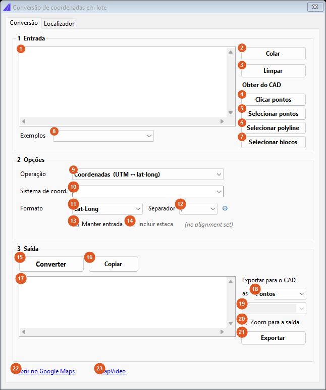
Tab 1, freshly opened: operation "Coordinates", format "Lat-Long", comma separator. The capture is of a Portuguese session; the numbering is the same in both editions, and the tables give the English captions.
Tab 1: Conversion — frame 1 Input
| # | Control | What it does |
|---|---|---|
| 1 | Input box | One coordinate per line. Blank lines stay blank in the output — they are deliberate spacing in a pasted column, not an error. Every change clears the conversion counter. |
| 2 | Paste | Pastes the clipboard text into box 1 (the same as Ctrl+V). |
| 3 | Clear | Empties the input, the output and the counter. |
| 4 | Click points | Hides the form and asks for points in the drawing, one after another, up to 200; each point becomes a line x y with three decimals. |
| 5 | Select points | Select entities: the first vertex of each one becomes a line. |
| 6 | Select polyline | Select one polyline: every vertex of it becomes a line. |
| 7 | Select blocks | The same as 5 — the first vertex of each selected entity. |
| 8 | Examples | A menu, not a setting: choosing an item fills box 1 with a sample and the box goes blank again. The five are UTM, Lat-long decimal, Lat-long DMS, BNG and Mixed. |
Tab 1: Conversion — frame 2 Options
| # | Control | What it does |
|---|---|---|
| 9 | Operation | Coordinates (UTM ↔ lat-long), Addresses → coordinates, Coordinates → addresses and Stations → coordinates. Only the first is available in this version — see Notes. Changing the operation enables or disables 10 and 11 according to what it needs. |
| 10 | Coord. system | The full list of system strings (WGS-84, Undefined, BNG and UTM-01S/UTM-01N through UTM-60S/UTM-60N). It comes filled with the system resolved for the drawing, on a pale green background. With no value here, Convert warns once, before running. Remember that most of this list does not resolve: see What actually converts. |
| 11 | Format | Lat-Long or Long-Lat: the order in which geographic pairs are read and written. |
| 12 | Separator | What separates the two fields in the output: ,, ;, a tab or a space. It has no effect at all on how the input is read — the ⓘ beside it says exactly that. |
| 13 | Keep input | The original line is repeated before the result, joined by the separator from 12. |
| 14 | Include station | Only enabled when an alignment is resolved; the grey label beside it reads eixo: current, or (no alignment set) when there is none. Ticking it does not change the output — see Notes. |
| 15 | Convert | Runs the operation over every line. The counter beside it then shows n of m converted, green when all passed and red, with "see !! lines", when not. |
| 16 | Copy | Copies the output (17) to the clipboard. |
Tab 1: Conversion — frame 3 Output
| # | Control | What it does |
|---|---|---|
| 17 | Output box | One line per input line, in the same order. Failed ones show !! followed by the reason (could not read two coordinates, coordinate system not set, conversion failed). Projected coordinates come out with three decimals, geographic ones with eight. |
| 18 | Export to CAD as | Points, Polyline or Blocks. See Notes: in this version all three export points. |
| 19 | Block name | Only enabled with Blocks chosen at 18. The list is empty and the value has no effect in this version. |
| 20 | Zoom to output | No effect in this version. |
| 21 | Export | Reconverts the input and draws the result on the current space and layer. With no line converted it warns that there is nothing to export; when it finishes it reports how many items were exported. |
Tab 1: Conversion — footer
| # | Control | What it does |
|---|---|---|
| 22 | Open in Google Maps | Converts the input and opens the browser on the first successfully converted line. With none, it asks you to convert a coordinate first. |
| 23 | CapVideo | Not available in this version. |
Tab 2: Locator
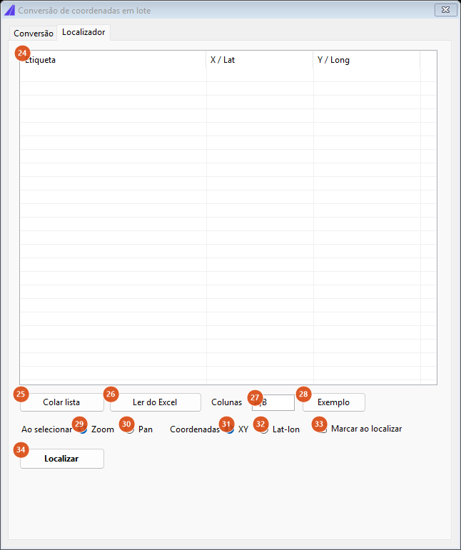
Tab 2, empty. The columns are Label, X / Lat and Y / Long. The capture is of a Portuguese session.
| # | Control | What it does |
|---|---|---|
| 24 | Places grid | One row per place, with a label and the two coordinates to six decimals. A place with no label shows as (sem nome) in grey. Selecting (or double-clicking) a row triggers the trip to it. |
| 25 | Paste list | Parses the clipboard text and fills the grid. Each line may come in either of two shapes: x y label (numbers first, the rest is the label) or label, x, y (the last two fields are the numbers). Lines that do not yield a pair of numbers are simply discarded — this list is navigation, not a conversion to paste back. |
| 26 | Read from Excel | Not available in this version: it says so and points you at Paste list (columns A,B). |
| 27 | Columns | The columns the Excel reader would use; in this version it only appears in the message from 26. Default A,B. |
| 28 | Sample | Fills the grid with four demonstration rows, in both shapes. |
| 29 | Zoom | When going to a place, zoom in on it. Default. |
| 30 | Pan | When going to a place, only centre the view, keeping the scale. |
| 31 | XY | The coordinates in the list are in the drawing's system. Default. |
| 32 | Lat-lon | The coordinates in the list are geographic and will be projected before the trip. A line recognised as geographic by the range of its values is projected anyway, even with XY ticked. |
| 33 | Drop marker on locate | Inserts a POINT at the place before going to it. |
| 34 | Locate | The same as double-clicking the selected row. |
Important: the "go to" is not available in this version — see Notes.
The entity form
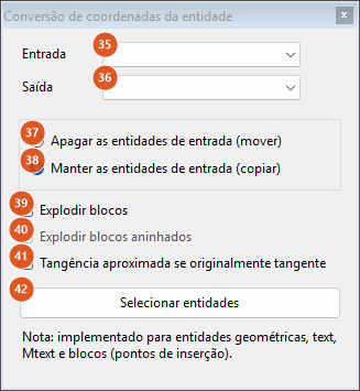
CAPCAD_GEO_CONVERT_ENTITY. The capture is of a Portuguese session in a Brazil profile, so both lists show the BR catalogue.
Under the button, the form carries the note "Note: implemented for geometric entities, text, Mtext and blocks (insertion points)."
| # | Control | What it does |
|---|---|---|
| 35 | Input | The system the entities are in today. In a Brazil profile the list is the BR catalogue (Undefined, UTM-18…UTM-26, the -SAD69 variants and WGS-84); outside it, the full catalogue. |
| 36 | Output | The target system. It must differ from 35. |
| 37 | Erase input entities (move) | The original entity is erased and the converted one takes its place. This applies only to entities treated as curves; blocks and text are shifted regardless, with no copy. |
| 38 | Keep input entities (copy) | The original stays and the converted one is added. Default. |
| 39 | Explode blocks | No effect in this version. Ticking it only enables box 40. |
| 40 | Explode nested blocks | No effect in this version; it starts disabled and is only enabled by 39. |
| 41 | Approximate tangency if originally tangent | No effect in this version. |
| 42 | Select entities | Hides the form, validates the two systems, asks for the selection in the drawing and converts. When it finishes, the command line reports n entity(ies) converted and, if any, , m failed. |
How the options combine
What input normalisation does to each line
Every line below was passed through the batch normaliser itself. The middle column is the text after normalising; the last, the pair read.
| You paste | Becomes | Read as |
|---|---|---|
795000 8874000 |
795000 8874000 |
795000 / 8874000 |
795000,8874000 |
795000 8874000 |
795000 / 8874000 |
-23,5505 -46,6333 |
-23.5505 -46.6333 |
−23.5505 / −46.6333 |
-23.5505, -46.6333 |
-23.5505 -46.6333 |
−23.5505 / −46.6333 |
-23.5505;-46.6333 |
-23.5505 -46.6333 |
−23.5505 / −46.6333 |
795000 + tab + 8874000 |
795000 8874000 |
795000 / 8874000 |
-23,5505,-46,6333 |
-23.5505.-46.6333 |
fails |
The rule: if the line has a tab or a semicolon, that is the separator and commas are decimal; if a space is left between the numbers, likewise (and a comma stuck to the space is discarded); only when the comma is the sole candidate separator is it treated as one, and even then only when exactly two fields are left. The last row of the table is the case the rule cannot solve: four comma-separated fields with comma decimals collapse into a single number.
Note the difference from the CAPCAD_GEO_POINT_IDENTIFY box, which accepts neither a space nor a semicolon: here the normalisation is deliberately more tolerant, because the raw material comes from a spreadsheet.
How the Locator reads each line
| You paste | Label | X | Y | Read as |
|---|---|---|---|---|
795000 8874000 Section start |
Section start | 795000 | 8874000 | projected |
Main square, 796000, 8874600 |
Main square | 796000 | 8874600 | projected |
-23.5505 -46.6333 |
(no name) | −23.551 | −46.633 | geographic |
no coordinate here |
— | — | — | discarded |
Remembered between sessions
Neither form keeps any option between sessions. What is reused on each opening comes from the drawing: the coordinate system resolved by the acquisition chain (see Coordinates and the coordinate system) and the active alignment.
Notes
- Only the Coordinates operation works. Addresses → coordinates and Coordinates → addresses are not available in this version: every line comes back as
!! Busca de endereços indisponível.or!! Busca reversa indisponível.. Stations → coordinates returns!! Stations→coordinates needs an alignment.on every line, even with an alignment set. To turn an address into a coordinate, use the Address panel ofCAPCAD_GEO_POINT_IDENTIFY. - The export to CAD always draws points. Polyline and Blocks also export points in this version, and the block-name box (19) has no effect.
- The Locator's "go to" is not available in this version. Selecting a row (or clicking Locate) inserts the marker, if 33 is ticked, and shows a message saying so. The Zoom / Pan options have no effect in this version.
- Include station and Zoom to output have no effect in this version. For the station of one point, use the Alignment km box of
CAPCAD_GEO_POINT_IDENTIFY. - The CapVideo link is not available in this version.
- Several strings are English-only, and a few are Portuguese-only. The ⓘ warning, the alignment label and the
n of m convertedcounter are English in every language; the failure reasons in the output box and the Addresses / Coordinates → addresses messages are Portuguese in every language. CAPCAD_GEO_CONVERT_ENTITYonly moves blocks and text between projected systems. If either the input or the output isWGS-84, insertion points are simply skipped in the selection — curves convert, blocks stay where they are.- Three boxes on the entity form have no effect in this version (39, 40 and 41).
- Choosing the same system on both sides is not a way to "not convert". The command refuses with an invalid-input message and selects nothing.
CAPCAD_BATCH_GEO_CONVERTexists on AutoCAD only. On the other CADs the name is registered, but ARES shows a feature-in-preparation notice and the other three do not register it.